| Pan | Pan the map by clicking and dragging the mouse pointer. | |
| Zoom Controls and Indicator |
 |
Zoom in and out by clicking the plus or minus buttons. The mouse wheel can also be used to zoom. Zoom level ( 0 - 18 ) is indicated between the control buttons. |
| Load GPX File |
Clicking this icon will bring up a dialog box which allows for selection of a GPX file with geocache coordinates for display on the map. Icons will be assigned to the geocache waypoints according to their type. (See map legend for decoder.) The geocache icon layer will be displayed above the state owned open space layer. The map code limits the GPX file size to approximately 1 MB. GPX files larger than that will not be displayed on the map. Depending on the complexity of the file this should allow for display of 50 - 100 caches on the map. Please report any problems that you may encounter with this feature. |
|
| Scale | The scale bar indicates the map scale as measured in feet and miles. | |
| Coordinates |
The coordinate bar shows the GPS coordinates of the mouse pointer. |
|
| Layers |  |
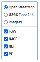
The upper portion of the layer selector panel will allow for choice between different base layers by clicking the corresponding radio button. Only one base layer can be displayed at a time.
The lower portion of the layer selector panel will allow for turning different overlay areas on or off by clicking the check box. Multiple overlay layers can be displayed at any time.
|
| Opacity |  |
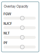
Use the sliders to increase or decrease the opacity of the individual overlay layers. |